


Features |
Specification |
|---|---|
|
Minimum Order Quality |
1 |
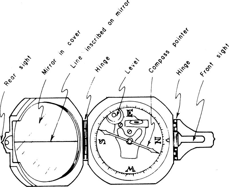
What is the Brunton Compass?
Brunton compass definition : a compact, pocket-sized instrument consisting of an ordinary compass, open sights, a mirror, and an inclinometer with a rectangular spirit level, which can be used by hand or on a light stick or stick to read angles horizontally and vertical, to level and read the magnetic bearing of a line. It is used for delineating mining work and for preliminary topographical and geological surface surveys, such as determining elevations, stratigraphic thicknesses, heading, and dip.
Construction Testing Equipments offers Brunton Compass Pocket Transit Type which is appreciated for its quality and reliability. The Brunton compass is used to measure the bearing, slope, and topographic survey of the skeleton. We ensure that the Brunton compass meets industry standards and specifications set by our customers. Enjoy Brunton’s precision-engineered compass at very competitive prices.
Features of Brunton compass:
- Precision manufacturing
- Strong
- Precision
- Smooth surface
Brunton compass parts and uses
Brunton compass parts and functions:
Now let’s discuss the use of the different parts.
Inclinometer Level
The inclinometer is used for:
- Align the vertical edge of the compass with the angle of the plane
- Adjust the inclinometer level
- Read the vernier scale angle on the compass
- Take tilt azimuth measurements
Bull’s Eye Level
- Used to take shot angle measurements.
Compass Needle
- Points to magnetic north and is damped by the magnet below the pivot. However, the bearing can be adjusted accordingly by turning the zero declination pin.
Compass
- 360 Degree Graduation Circle – Used for azimuth readings with half a degree accuracy.
Clinometer Scale
- To measure immersion using the long spirit level on the vernier scale.
Raise the needle pin
- Helps to fix the needle to take a measurement.
Vernier
- The vernier is used to measure the slope with an accuracy of 30 minutes.
Brunton compass Diagram
What is a Brunton compass used for?
Brunton Compass Uses:
Geologists use the Brunton compass for various purposes in the field. It is a very useful tool for measuring angles, dips, and strikes.
The device is also used for:
- Determination of magnetic declination
- The notion of domain
- Attitude measurement
- Measure the bearing of a line between two points
- Use the compass for the two-point problem
- Blow and dip measurement
- Direction and land maps
Brunton Compass How to use
Here are the steps to know how to use Brunton Compass
- Place the LOWER EDGE of the compass on the plane to be examined.
- Adjust the compass orientation, making sure the bottom edge is still flat against the plane until the air bubble is centered on the ‘Target Plane’.
- Read each end of the compass needle to obtain the eccentricity value.